


By Rajai M. Nuseibeh
Airport codes are meant to be administrative shorthand – neutral, functional, forgettable. But in Jerusalem, even three letters can become a battleground of identity. For much of the twentieth century, the city was marked by JRS, the code of its historic airport and a symbol of its Arab and regional connectivity. Today, a state-led branding shift toward JLM – drawn from the Hebrew Yerushalayim – is being deployed across official campaigns, signage, and global marketing. This seemingly minor change is part of a far larger story: the steady restructuring of Jerusalem’s geography, demography, and memory. This shift functions not as mere rebranding but as a symbolic extension of policies that have reshaped Jerusalem’s physical and demographic landscape since 1967, embedding even language and symbols into the machinery of annexation.
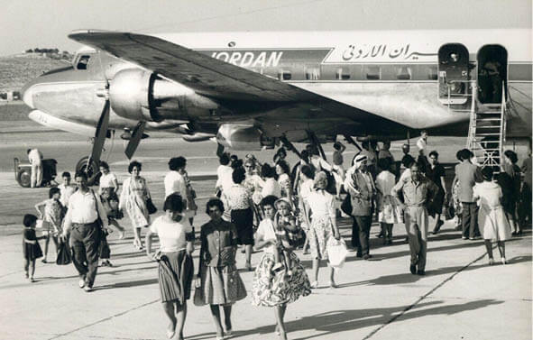
JRS once stood for Jerusalem Airport – a modest airfield first laid down by the British in the 1920s and opened to regular civil flights in 1936.1 From that year onward, Palestine Airways and Imperial Airways carried Palestinians and international passengers from Jerusalem to Cairo, Beirut, Baghdad, and beyond.
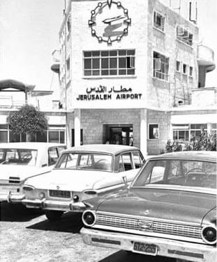
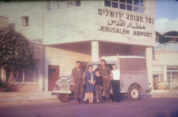
Under Jordanian administration (1948–1967), it was officially known as Jerusalem Airport (Matar al-Quds), and the code JRS was printed on tickets and timetables.2 Airlines such as MEA and Alia/Royal Jordanian made it a true gateway tying Al-Quds to the Arab world.
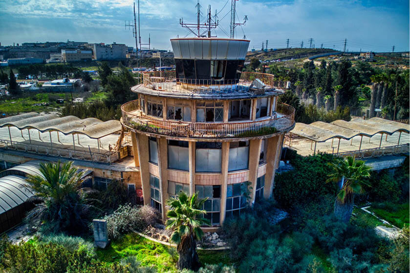
JRS and JLM are three letters that tell a city’s story: The ghost runway of Al-Quds.
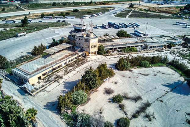
All of that ended in 1967, when Israel occupied East Jerusalem and seized the airport.3 The terminal was renamed, flights dwindled, and by 2000, at the start of the Second Intifada, all civilian traffic stopped. Today, the runway lies abandoned – apart from Israeli plans to transform it into a new Jewish-only settlement of more than 9,000 housing units.4 If built, it would further strangle the surrounding Palestinian villages and cut East Jerusalem off from its natural connection to Ramallah and the rest of the West Bank.
What happened to Jerusalem in 1967 was not new. Two decades earlier, it happened in al-Lydd. When the British built Palestine’s main international airport in 1936,5 they named it Lydda Airport, after the thriving Palestinian town of Al-Lydd on whose lands the runways were laid. For a decade, it was the hub of Palestine’s skies.
In July 1948, during Operation Dani, Palmach forces led by Yigal Allon and his deputy Yizhak Rabin, at the time a young officer in the Yiftah brigade, stormed the town. Within days, more than 50,000 to 70,000 Palestinians – Muslims and Christians alike – were expelled from Al-Lydd and nearby Ramle. Hundreds were killed in Al-Lydd in some of the bloodiest massacres of the war: the dahmash mosque massacre and the “Lydda Death March,”6 where families were forced to walk for miles in the summer heat without food or water. Only a fraction of the original Palestinian Arab inhabitants remained, living under military rule.
Lydda: Another city, the same story.
The town itself was renamed Lod. The airport became Lod Airport, and in 1973 it was rebranded once more as Ben-Gurion Airport. Today Lod is home to some 80,000 residents, but only 20 to 25 percent of them are Palestinian Arabs.7 The rest are Jews who resettled there after the expulsions of the Indigenous population: Mizrahi families from Arab countries moved here in the 1950s, later waves came from the Soviet Union and Ethiopia.
The logic was clear: Uproot the population, repopulate the town, rename the airport, erase the history. What was done in al-Lydd in 1948 would later be applied to Jerusalem after 1967 – only this time to the political and spiritual center of Palestine.
In June 1967, after the Six-Day War, Israel occupied East Jerusalem and within weeks redrew the city’s map. The municipal boundary was unilaterally expanded by 70 km2, annexing the Old City and surrounding Palestinian neighborhoods, along with land from 28 nearby villages. The line was drawn not to serve residents, but to secure ratios: maximum land with minimum Palestinians. Those absorbed into the new borders were denied citizenship and instead labeled “permanent residents” – a fragile status that could be revoked at any time.
On these confiscated lands, Israel began constructing new Jewish “neighborhoods.” Ramat Eshkol was built on the lands of Lifta and Shu‘fat. French Hill rose on lands from Issawiya and Shu‘fat. Pisgat Ze’ev sprawled across the fields of Beit Hanina and Hizma. Neve Yaakov, abandoned in 1948, was reestablished in 1970 on more land from Beit Hanina. Gilo was planted on the orchards of Beit Jala, while Har Homa claimed Jabal Abu Ghneim, once owned by families of Beit Sahour and Sur Baher.
While Al-Quds was annexed through urban planning, the illegal Separation Wall has drawn another line on the map, slicing not only through the West Bank but also through Jerusalem’s neighborhoods.
By 2025, more than 57,000 housing units had been built in these new neighborhoods, housing over 150,000 Jewish Israelis on confiscated Palestinian lands – all with direct government and municipal support. In the same period, fewer than 600 units were approved for Palestinians. Confined to just 13 percent of East Jerusalem’s land, most of it already built up, Palestinians face a near-total blockade on permits. Thousands of homes have instead been demolished, criminalizing Palestinian presence while expanding space for Israelis.
The project only widened. The so-called “Greater Jerusalem” plan seeks to extend the city’s footprint even further, linking it to the massive settlement of Ma‘ale Adumim (40,000+ residents) through the planned E1 corridor. If completed, it would cement Israeli control over the Jerusalem periphery while cutting the West Bank into two – severing the north from the south, and East Jerusalem from its natural Palestinian hinterland.
Demolition and residency policies have reinforced the same goal. Since 1967, more than 2,600 Palestinian homes have been torn down in East Jerusalem; in 2024 alone, 181 homes were demolished – the highest figure ever recorded.8 Residency itself became a weapon: Israel has revoked the legal status of nearly 15,000 Palestinians, severing their ties to their own city and pushing them outward.
The demographic balance shifted as planned. At the end of the First World War, Jerusalem’s population was around 75 percent Palestinian Arabs (Muslims and Christians) and 25 percent Jews. By the final British census in 1946, Palestinians still made up nearly 60 percent of the city. After 1948, entire Arab neighborhoods in West Jerusalem – Talbiyeh, Qatamon, Baq‘a – were emptied and their residents barred from return under the Absentees’ Property Law. After 1967, East Jerusalem was annexed, and its 66,000 Palestinians downgraded to residents rather than citizens.
Today, Jerusalem has a population of roughly 1 million people: about 61 percent Jews and 39 percent Palestinians. The numbers are not natural; they are engineered – the product of decades of land confiscation, settlement construction, residency revocations, and house demolitions.9
If 1967 redrew the city once, the 2000s cut it again. Israel’s Separation Wall, declared illegal by the International Court of Justice in 2004, did more than divide the West Bank – it sliced through Jerusalem itself.10 Entire Palestinian-majority neighborhoods – Shu‘fat Refugee Camp, Kafr ‘Aqab, Samiramis, Al-Ram, Bir Nabala – were pushed to the “outside.” Families in these areas still carry Jerusalem IDs and pay Jerusalem taxes, yet they must pass through military checkpoints to reach their own schools, workplaces, and hospitals. At the same time, these neighborhoods receive almost no municipal services: garbage piles up uncollected, streets go unpaved, schools remain underfunded.
“If I don’t steal it, someone else will.”
In the south and east, the same story unfolded. Abu Dis and Al-‘Eizariya (Bethany), suburbs historically tied to Jerusalem, were excluded from the city’s municipal boundary and then walled off in the 2000s, cutting them off from Al-Quds and leaving residents dependent on permits for access. The village of Al-Walaja lost most of its lands to annexation and now sits encircled by the Wall, accessible only through a single checkpoint. Parts of Sur Baher, Jabal Mukabber, and Um Tuba were also fragmented, some sections inside the annexed Jerusalem, others trapped outside.
The Wall was not built for security alone; it was another act of cartography in the service of demography. By running its course where it did, Israel effectively scratched off nearly 150,000 Palestinian Jerusalemites from the functional life of the city. On paper, they remain residents. In practice, they have been excluded from the urban core, their presence diluted in statistics, their neighborhoods left to decay.
For Palestinians, the Wall did not just cut land; it cut memory and belonging. It turned the simple act of reaching Jerusalem’s Old City – Al-Aqsa Mosque, the Church of the Holy Sepulcher – into a journey of checkpoints and permits. Another line on the map had re-engineered the city, not by removing people directly, but by walling them out of their own capital.
The story of Jerusalem, is put forward in simple words by Jacob Fauci, a settler from New York. Brought by extremist settler organizations all the way from the United States to Israel, he moved into part of the Al-Kurd family’s house in Sheikh Jarrah – property that Palestinian refugees have lived in since 1948. Settler groups have targeted Palestinian homes built by the Jordanian government for families displaced in 1948, such as the Al-Kurd home, based on pre-1948 claims revived only for Jewish litigants.
Across town, the story is reversed but the outcome identical. In the once-elegant Arab neighborhoods of Talbiyeh, Baq‘a, and Qatamon, Palestinian Arabs were forced out in 1948, their homes seized under the Absentees’ Property Law (1950) – a 1950 Israeli law that classifies Palestinians displaced or prevented from returning as ‘absentees,’ even if they were only a few kilometers away, and transfers their property to the state without compensation, forming the legal basis for the confiscation of over 4 to 5 million dunams of Palestinian land and tens of thousands of Palestinian homes since 195011 – and the neighborhoods absorbed into Israeli West Jerusalem.12 Families such as the Khourys, Nashashibis, Husseinis, and Dajanis still hold the title deeds to their villas but are barred from ever reclaiming them.
The contradiction is deliberate. Palestinians expelled from their homes in West Jerusalem or historical Palestine (Yafa, Akka, Haifa, Al-Lydd) cannot return, while Jewish settlers arriving from abroad are legally empowered to take homes in East Jerusalem. Different mechanisms, opposite directions – but the same outcome: displacement of Palestinians and demographic engineering of the city.
The battle over Jerusalem is fought with borders, bulldozers, and laws – and increasingly with symbols as small as three letters. JRS once stood for a city that looked outward, connected to its surrounding Arab world through an airport, a code, a culture and a history rooted in its Muslim and Christian inhabitants.
Since 1967, that city has been systematically reshaped: municipal boundaries expanded, land confiscated, settlements built, homes demolished, residencies revoked, and families uprooted by discriminatory laws or by force. Palestinians were walled out of their own capital, and whole neighborhoods were recast in Hebrew names.
Now, even the abbreviation is being rewritten. Israeli municipal branding pushes JLM – lifted from Yerushalayim – across tourism posters, city logos, and sports campaigns. It is presented as neutral shorthand, but it is anything but. It is another layer in the long project of erasure: to overwrite JRS, to deny the Palestinian Arab history of Jerusalem, and to impose a new identity that serves the occupier.
Three letters tell the story. JRS: an airport code that anchored the city in its Arab surroundings, both physically and culturally. JLM: a branding device of annexation and demographic engineering. Between the two lies the history of a city under occupation – its land divided, its people displaced, its memory rewritten. From JRS to JLM: three letters that encapsulate the annexation of a city.
1 B’Tselem, “East Jerusalem: Policy of Discrimination” (2019, updated 2023).
2 Ir Amim, Annexation and Inequality in Jerusalem (2015–2024).
3 United Nations Security Council, Resolution 252 (1968).
4 Peace Now, “Jerusalem Settlement Reports” (2022–2024).
5 Salim Tamari, Jerusalem 1948: The Arab Neighborhoods and Their Fate (1999).
6 Benny Morris, The Birth of the Palestinian Refugee Problem, 1947–1949 (1987); see also Zochrot and Al-Haq. Oral Histories of the Nakba: Lydda and Ramle, 1948. Jerusalem and Ramallah: Zochrot and Al-Haq.
7 Israeli Central Bureau of Statistics, Statistical Abstract of Israel (2024).
8 Israeli Committee Against House Demolitions (ICAHD), Statistics on House Demolitions, 1967–2024. Jerusalem: ICAHD, 2024; OCHA (United Nations Office for the Coordination of Humanitarian Affairs), Demolition Database. Jerusalem: OCHA, 2024.
9 OCHA, East Jerusalem Humanitarian Factsheets, Jerusalem: OCHA, 2022–2023.
10 International Court of Justice, Advisory Opinion on the Legal Consequences of the Construction of a Wall in the Occupied Palestinian Territory, The Hague: ICJ, 2004; Amnesty International, Israel’s Apartheid Against Palestinians, London: Amnesty International, 2022; and B’Tselem, The Separation Barrier, Jerusalem: B’Tselem, 2023.
11 See Absentees’ Property Law, 5710–1950; United Nations Conciliation Commission for Palestine (UNCCP), Progress Report on Refugee Properties (1951); HaMoked, The Quiet Deportation (1997; updated 2018); Benny Morris, The Birth of the Palestinian Refugee Problem (1987); Walid Khalidi, All That Remains (1992).
12 See also B’Tselem, Revocation of Residency in East Jerusalem, Jerusalem: B’Tselem, 2021; HaMoked, The Quiet Deportation, Jerusalem: HaMoked, 1997; updated 2018.

Rajai M. Nuseibeh is a technology and economic development strategist with over 18 years of experience in building inclusive innovation ecosystems across East Jerusalem, Palestine, the larger MENA region, and Eastern Europe. He has led programs that expand employment and entrepreneurship, empower women and youth, and strengthen grassroots leadership in underserved communities. His work includes partnerships with institutional and government donors such as USAID, the World Bank, and the EU, alongside leading private-sector actors, advancing models that link digital innovation with social and economic impact. Nuseibeh is also active in community leadership, philanthropy, and civic initiatives in Jerusalem.
